
By Dr. Sara Kelly, Research Scientist
Wake Boats are Operating on Adirondack Park Waters
Our September 2026 blog post highlighted that wake boats are launching on several Adirondack waterbodies, including approximately 60% of high-traffic lakes and ponds monitored by the Aquatic Invasive Species Spread Prevention Program operated by AWI. Although the Adirondack Park contains more than 11,000 lakes and ponds, many are small, remote, and may be unsuitable for large, trailered boats such as wake boats.
This article explores six large, popular Adirondack lakes to illustrate an important distinction: having abundant water does not mean having sufficient space for wake sports. Even large lakes and ponds may lack an open water area where the depth and distance from shore can accommodate wake sports while minimizing impacts on the environment and other recreational users.
Wake boats with large ballast tanks or modifications designed to produce large, surfable wakes can mobilize lake-bottom sediments and nutrients, erode shorelines, damage aquatic and nearshore habitats, create hazardous conditions for boaters and swimmers, disturb loon nests, and damage docks and moored boats. To help minimize these impacts, responsible operation calls for maintaining a distance of at least 500 feet from shorelines and other recreationists, operating in water at least 30 feet deep, and using zones that provide at least 100 continuous acres of suitable water with dimensions of at least 3,000 feet long by 200 feet wide. These wake smart criteria also help provide room for separate passes rather than repeatedly disturbing the same area.
What We Know about Adirondack Waters
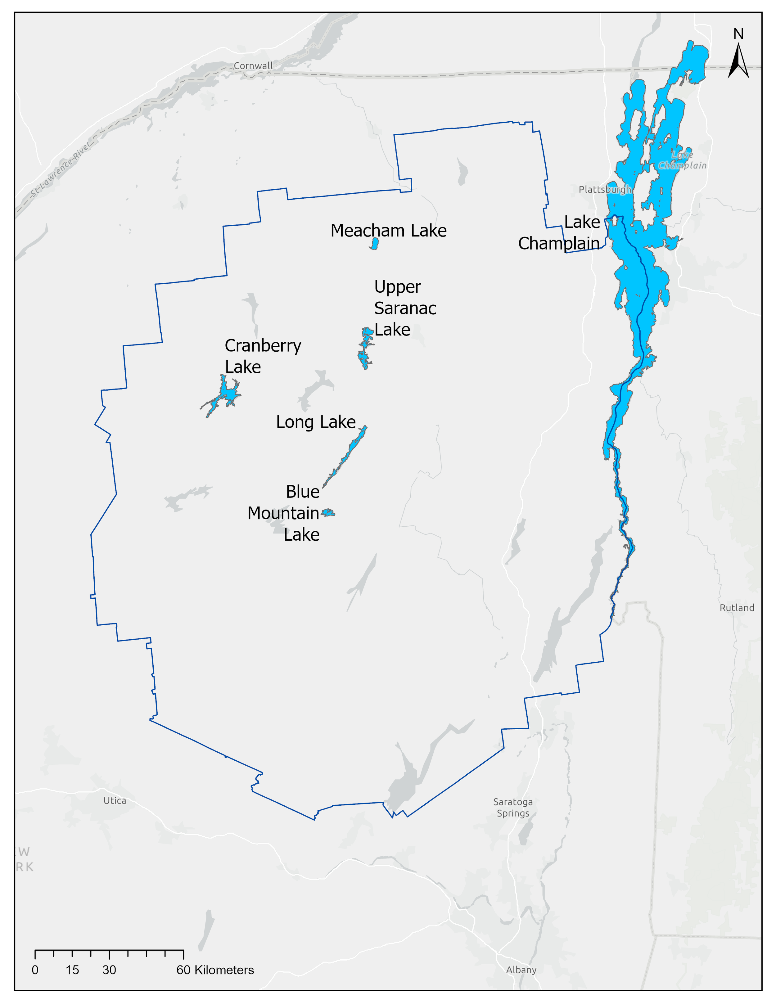
Figure 1. Map of the Adirondack Park, with the six lakes mentioned in this article highlighted (Credit: Sara Kelly).
Most Adirondack lakes and ponds lack publicly available digital bathymetric maps, which show lake-bottom topography and water depth. This data gap prevents a comprehensive, systematic Geographic Information Systems (GIS) analysis of wake smart zones across the Adirondack Park. The examples in this article therefore rely primarily on information from purchased fishing maps published by Sportsman’s Connection and publicly available fishing maps from the New York State Department of Environmental Conservation (NYS DEC). AWI has compiled an inventory of 200 Adirondack waterbodies with known surface areas. Of these, only about 9% are considered large by Adirondack standards, with surface areas exceeding 1,000 acres.
The six case studies below examine how lake size, depth, shoreline configuration, islands, and underwater topography affect the amount of water that may be suitable for responsible wake sports. Together, they illustrate why even some of the Adirondack Park’s largest lakes cannot accommodate wake sports across most or all of their surface area without compromising environmental protection and shared recreational use.
Large Lakes May Still Be Too Small for Wake Sports – Exploring Depth and Distance-from-Shore Guidance
Case Study 1: Cranberry Lake – Sizable but Shallow with Numerous Narrows
Cranberry Lake in St. Lawrence County is the Adirondacks’ third largest lake by surface area, covering nearly 7,000 acres. Although its maximum depth of 38 feet exceeds the recommended 30-foot minimum, its average depth is only 6 ft. Consequently, much of the lake is too shallow to meet the recommended depth for responsible wake boat operation for wake sports.
The lake’s numerous islands and narrow arms further limit the potential for suitable wake smart zones. Maintaining a 500-foot setback from shoreline in sufficiently deep water leaves only one area near the eastern side of the main lake that may be suitable. Without detailed bathymetry, the precise extent of this area is uncertain, but preliminary estimates suggest it would represent less than 10% of the lake’s total surface area.
Case Study 2: Long Lake – Large but Narrow and Mostly Shallow
Long Lake in Hamilton County covers just over 4,000 acres. Despite a maximum depth of 50 feet, its average depth is only 13 feet, and most of the lake is less than 20 feet deep.
Long Lake’s narrow shape presents an additional challenge. The lake averages approximately half a mile in width, and some sections are less than 500 feet from shore to shore. Its deepest area is relatively small and lies next to an island, further limiting the space available for responsible wake boat operation. Taken together, the lake’s depth and configuration leave insufficient room for wake boats to maintain appropriate setbacks and make separate passes without repeatedly disturbing the same area.
Wake boats were inspected at Long Lake during the summer 2026 season, suggesting that wake boat traffic is already occurring despite the lake’s likely inability to accommodate responsible wake sports under the recommended criteria. Long Lake may therefore benefit from targeted education and consideration of local regulations to protect this important community and regional resource.
Case Study 3: Blue Mountain Lake – Deep Water, but Complex Bottom Topography and Islands
Blue Mountain Lake in Hamilton County is a large lake by Adirondack standards, covering more than 1,000 acres. It is also relatively deep, with a maximum depth of 100 feet and an average depth of 46 feet. Its mostly elliptical shape and relatively regular shoreline might initially suggest favorable conditions for wake sports.
However, irregular underwater topography and the presence of islands complicate the picture. These features restrict the amount of water that meets both the depth and distance-from-shore recommendations, potentially leaving only small areas, if any, suitable for responsible wake sports.
Case Study 4: Upper Saranac Lake – Islands, Irregular Shoreline, and Complex Bathymetry
Upper Saranac Lake in Franklin County covers more than 5,000 acres, with a maximum depth of 85 feet and an average depth of 33 feet. Unlike the more regular outline of Blue Mountain Lake, Upper Saranac Lake has an irregular shoreline and distinct northern and southern basins. It also contains numerous islands and areas of complex underwater topography.
These characteristics limit the lake to five relatively small potential wake smart zones, together accounting for approximately 27% of its total surface area. In other words, even a large, relatively deep lake may have only about one-quarter of its surface area available for wake sports when a 500-foot shoreline setback and a minimum water depth of 30 feet are applied.
Case Study 5: Meacham Lake – Favorable Conditions but Still a Fraction of the Lake Suitable for Wake Sports
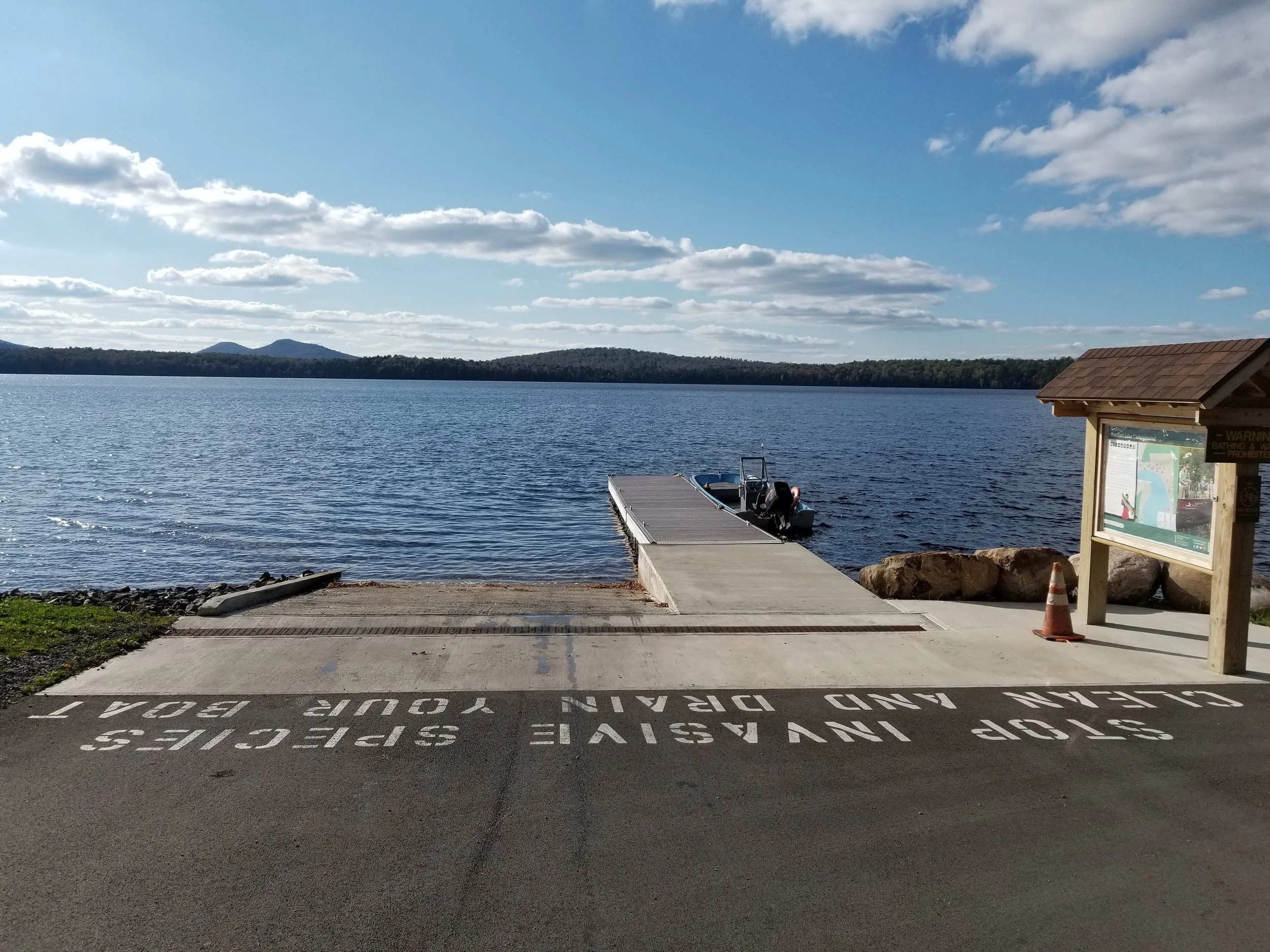
Meacham Lake boat launch.
Meacham Lake in Franklin County covers approximately 1,200 acres. It’s relatively deep, with a maximum depth of 80 feet and an average depth of 36 feet, and has a regular, elliptical shape with a smooth shoreline.
The bathymetry of Meacham Lake shows relatively evenly spaced depth contours, indicating a gradual slope toward the lake’s deepest area near the center. The absence of islands and other major geographic complications makes Meacham Lake one of the more favorable examples for identifying a large, continuous wake smart zone.
Even under these comparatively favorable conditions, however, preliminary estimates suggest that the deeper water suitable for wake sports accounts for only about 55–65% of the lake’s total surface area. This means approximately one-third to nearly one-half of the lake may remain unsuitable under the recommended depth and distance-from-shore criteria.
Case Study 6: Lake Champlain – Exceptionally Large and Deep Lake, but Wake Sports Not Appropriate Everywhere
Lake Champlain is the 13th-largest lake in the United States and reaches nearly 400 feet deep, roughly twice the maximum depth of Lake George to the southwest. Its average depth is approximately 64 feet. Given its immense size, about 120 miles long and 12 miles wide, and its substantial depth, it might seem that most of the lake could accommodate wake sports.
However, Lake Champlain’s size and depth do not eliminate the limitations created by its shape, islands, and underwater topography. GIS analysis of publicly available bathymetry suggests that approximately 55% of the lake is suitable for wake boat operation under the recommended criteria. The South Lake and Missisquoi Bay are generally too shallow or too narrow to provide sufficient room for responsible operation, while larger portions of the Main Lake, Malletts Bay, and the Northeast Arm offer more favorable conditions.
Lake Champlain demonstrates that even exceptionally large and deep lakes have substantial areas where wake sports may not be appropriate.
Conclusion – Lake Size Alone Does Not Determine Where Wake Sports Belong
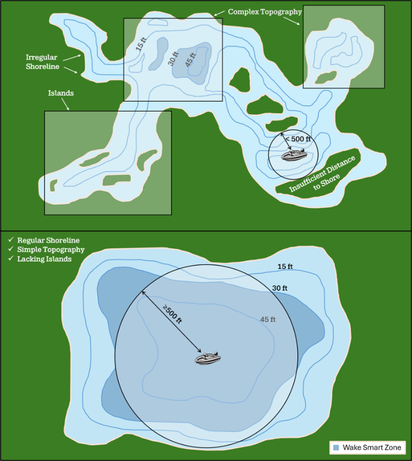
Figure 2. Top: example lake with an irregular shoreline, complex topography, and islands with a very small area of the lake meeting depth and distance from shore criteria for suitable wake smart zones. Bottom: example lake with a regular shoreline, simple topography, and no islands with approximately 50% of the lake suitable for wake sports (Credit: Alec Cimini).
The six case studies illustrate a consistent finding: a lake’s total surface area does not tell us how much of – or whether – it can safely and responsibly accommodate wake sports. Depth, shoreline configuration, islands, underwater topography, and the need to maintain adequate distances from shore and other recreationists all determine whether suitable wake smart zones exist and how much usable space they provide (Figure 2).
Even among the Adirondacks’ largest lakes, the amount of potentially suitable water varies considerably. On Upper Saranac Lake, for example, only about 27% of the total surface area falls within five potential wake smart zones. Meacham Lake, which has a comparatively favorable shape, depth profile, and shoreline, may offer suitable conditions across 55–65% of its surface area. And even Lake Champlain, an exceptionally large and deep waterbody, is estimated to have suitable conditions across only about 55% of its area. These results are consistent with the percent of total lake area that mapped wake smart zones cover in Vermont as well.
These examples suggest that suitable wake smart zones may be even more limited on smaller Adirondack lakes and ponds. They also reinforce the importance of considering not just the size of a potential zone, but its configuration: responsible and wake smart operation requires enough continuous space to maintain setbacks and make separate passes without repeatedly disturbing the same area.
Responsible Wake Boat Operation Awareness is Critical to Safeguarding Adirondack Waters
These examples highlight an opportunity to focus education and management efforts on lakes where we know wake boats are already present, but also where suitable operating areas may be limited or nonexistent. Raising awareness of depth, shoreline setbacks, and the need for sufficient open-water space can help boaters understand where their activities may create avoidable impacts. Where appropriate, communities may also wish to consider local regulations to protect natural resources and support the safe, shared use of their waters.
Better Bathymetric Data Are Essential
A major obstacle to identifying suitable wake smart zones across the Adirondack Park is the lack of detailed, publicly available bathymetric data. Without reliable information about lake depth and bottom topography, it is difficult to determine where the recommended criteria can be met or to estimate how much water is available for responsible wake sports.
A more comprehensive assessment should begin with popular lakes where wake boat use is known or anticipated, including Brant Lake and Indian Lake. Mapping these and other priority waterbodies would allow AWI and its partners to conduct more systematic GIS analyses, identify potential wake smart zones, and better inform public education and local decision-making.
Ultimately, the Adirondacks’ abundance of lakes and ponds should not be mistaken for an abundance of suitable wake sport waters. Responsible wake boat use depends on having enough deep, open water, not simply a large lake. Until more comprehensive bathymetric data are available, case-by-case assessments are essential to understanding which Adirondack waters may be able to accommodate wake sports, and which may be too constrained to do so responsibly.